Trail Walking La Salvetat-Peyralès - pont de la roque - Photo
 grfr12
grfr12

User

© OpenStreetMap contributors
Length
Length
10.8 km
Max alt
Max alt
480 m
Uphill gradient
Uphill gradient
317 m
Km-Effort
Km-Effort  
15 km
Min alt
Min alt
221 m
Downhill gradient
Downhill gradient
317 m
Boucle
Boucle
Yes
Creation date :
2017-03-30 00:00:00.0
Updated on :
2017-03-30 00:00:00.0

(0 Reviews)

Walking
Walking
3h15
Difficulty : Medium

Scan this QR Code to open this trail in the SityTrail application

FREE GPS app for hiking

Logo SityTrail SityTrail

IGN / Geographical institutes

Download SityTrail from the App Store Download SityTrail from Google Play

Logo SityTrail SityTrail World

The world is yours!

Download SityTrail from the App Store Download SityTrail from Google Play Download SityTrail on Huawei AppGallery

About

Trail Walking of 10.8 km to be discovered at Occitania, Aveyron, La Salvetat-Peyralès. This trail is proposed by grfr12.

Elevation profile

Points of interest

Point of interest La Salvetat-Peyralès - Point 1 - Photo
grfr12
LA SALVETAT-PEYRALÈS 

Positioning

Country:
France
Region :
Occitania
Department/Province :
Aveyron
Municipality :
La Salvetat-Peyralès
Location:
Unknown
Start:(UTM)
432691 ; 4893345 (31T) N.

Trails nearby

Trail Walking Jouqueviel - Le Tel Jouqueviel - Photo
Walking
tercla

Walking

Difficult
Jouqueviel, Occitania, Tarn, France
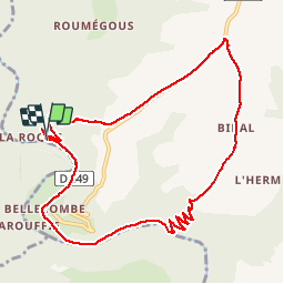
18.7 km | 27 km-effort
6h 4min
Yes
Trail On foot Jouqueviel - Sentier de Lauretié et de l’Ouradou - Photo
On foot
GUIDE+

On foot

Easy
Jouqueviel, Occitania, Tarn, France
11.3 km | 16.1 km-effort
3h 40min
Yes
Trail On foot Jouqueviel - 2023-03-20_14h22m10_Cirkwi-Sentier_pédestre_Lauretie_et_L_Ouradou - Photo
On foot
tercla

On foot

Easy
Jouqueviel, Occitania, Tarn, France
11.4 km | 16.4 km-effort
3h 43min
Yes
Trail Walking La Salvetat-Peyralès - Bibal par la vallée du Viaur - Photo
Walking
Patrick Gonfalone

Walking

Medium
La Salvetat-Peyralès, Occitania, Aveyron, France
7.5 km | 11.5 km-effort
2h 37min
Yes
Trail Walking Mirandol-Bourgnounac - 12_La Rivière - Photo
Walking
jab31

Walking

Very easy
Mirandol-Bourgnounac, Occitania, Tarn, France
22 km | 32 km-effort
5h 7min
Yes
Trail Walking Jouqueviel - 81_Jouqueviel - Photo
Walking
jab31

Walking

Medium
Jouqueviel, Occitania, Tarn, France
10.8 km | 15.4 km-effort
2h 12min
Yes
Trail Running Jouqueviel - Le Tel par Bibal 24km - Photo
Running
J-Mi

Running

Medium
Jouqueviel, Occitania, Tarn, France
23 km | 33 km-effort
Unknown
No
Trail sport Castelmary - Clapas 10.9km - Photo
sport
zakouski

sport

Very easy
Castelmary, Occitania, Aveyron, France
10.9 km | 14.5 km-effort
Unknown
Yes
Trail Walking Jouqueviel - le tel  vicasse - Photo
Walking
Frayssinet

Walking

Medium
Jouqueviel, Occitania, Tarn, France
25 km | 36 km-effort
7h 42min
Yes


Close
My subscriptions